GETTING INTO THE PARK // JULY 15, 2015
We stayed just outside of the park in Fresno, CA with two friends we planned on hiking with - Nick and Haze. They were pretty familiar with the trails, so they led the way! We took Highway 41 north into Yosemite and parked in the Yosemite Valley. But before catching the shuttle bus to The Mist Trailhead, we walked over to the Bridalveil Falls.
SETTING OUR PLAN //
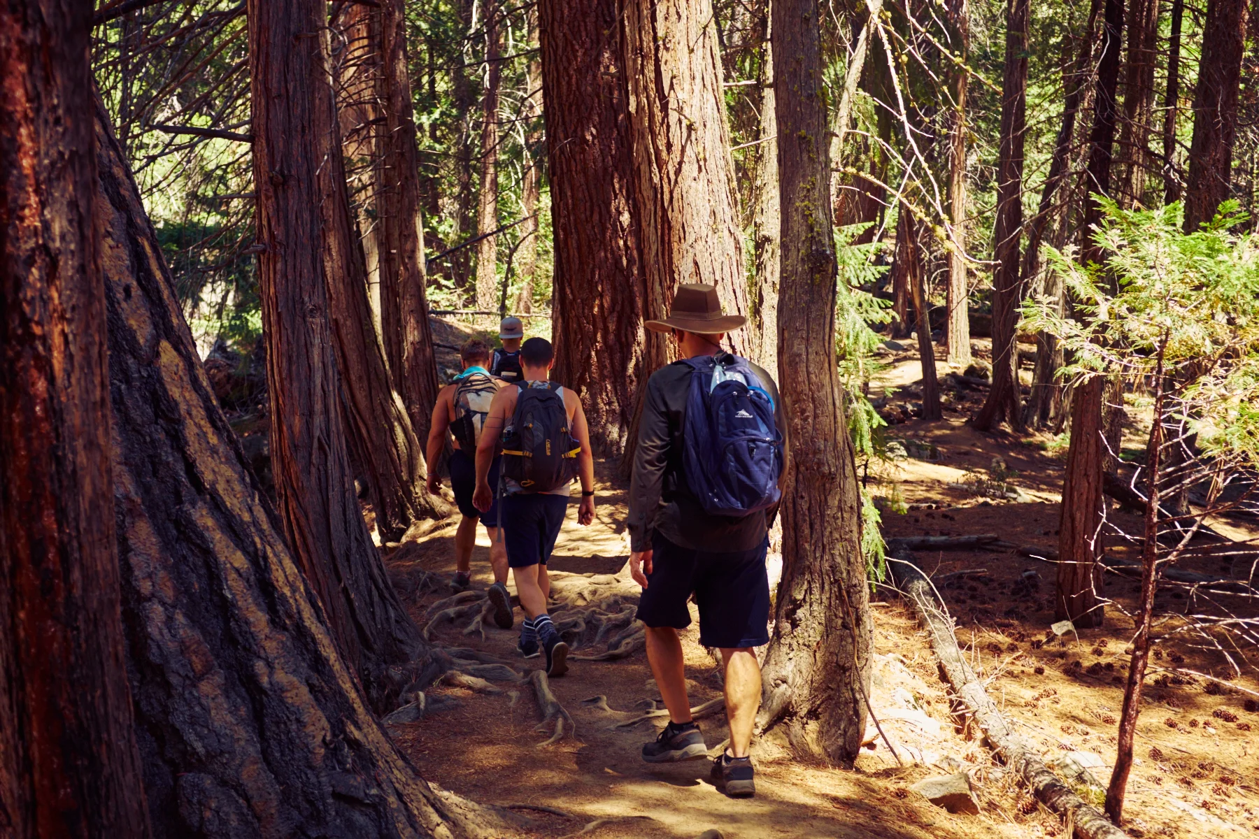
Our plan was to hike Yosemite's signature trail: the punishing but majestic Mist Trail. The 3.5 mile, one-way trail offers a steep, intimate experience of the Vernal and Nevada Falls with an elevation gain of 1,900 feet. From there, we took the Panorama Trail to connect to Glacier Point. A 9.5 mile, one-way hike estimated at six to eight hours.


THE TRAIL // TO VERNAL FALLS
The first mile of the Mist Trail was a strenuous, paved trail, followed by a half-mile hike up a misty, granite-laid staircase that traced the Merced River. The narrow path became pretty challenging before we reached our first stop: Vernal Falls at 317 feet. It was tough to capture photos of our surroundings without a wide angle lens. Also, without people in the photos, there is no sense of scale. We spent about half an hour getting closer to the falls, climbing on the rocks amongst the mist and taking it all in.
We then climbed the side of the falls on a path that consisted of a narrow staircase with two wires for handrails on either side. People were passing in both directions, so we had to stop and awkwardly shimmy past people. It was quite strenuous. The gusts of mist coming from the falls felt amazing, but it made the steps wet and slippery, so we had to take our time. Once we made it to the observation area at the top of Vernal, we stood looking out over the valley, breathing in all the fresh air.


LUNCH AT THE NATURAL WATER SLIDES //
We decided to take a quick lunch break and ate our PB&J sandwiches while we watched people go down the natural waterslides at Emerald Pool. The slippery granite slope, called the Silver Apron, looked pretty challenging from where we sat. I researched afterward, and there are a ton of injuries there every year; many people have even been killed after being swept over the falls. I would never take the chance, considering the remoteness and how far you'd have to walk to get help if needed. For that reason, they do not recommend swimming in this area. In fact, swimming and wading are prohibited at Emerald Pool, and signs are clearly marked advising against such recreation.
A little further up, people were relaxing in the streams and floating in the water holes. It looked incredibly relaxing. I wished we had brought our bathing suits, but I know I would have never wanted to get out of the water if I had. Next time! Also on the trail, we passed a lot of children, and I wondered what it would be like to see the scale and beauty of Yosemite with such young eyes.


ONTO THE NEVADA FALLS //
From there we trekked on to the next set of falls, standing at 594 feet. Once we reached the bottom of the falls, we started up the super steep incline along the base of the falls on a set of rough and uneven stairs. Again, there was a decent amount of foot traffic that required us to constantly look up to see what was ahead of us on the trail; it made it difficult also to focus downward to make sure our footing was solid. At one point, I started to feel light-headed and dizzy and began questioning every step. I took a couple of breaks and wondered how I would conquer the next 8 miles. It turns out my sugar was low. Within half an hour of having a snack, I started to feel better and was able to make it to the top of the Nevada Falls. It was so amazing to be so close to such a powerful force of nature. Each leg of the trail was more difficult than the last. At this point, the elevation gain was 1,900 feet, and we were about 3.5 miles into our 10-mile hike.


CONNECTING TO THE PANORAMA TRAIL //
We soon came to a fork in the road along the John Muir Trail. I was a little nervous when the sign read “Glacier Point 4.6 Miles” because it meant we weren't even halfway there yet. And I'd be lying if I said that I wasn't feeling a little exhausted. Nonetheless, we had a goal, and the guys gave me the encouragement I needed. For the next mile or so, the incline was very gradual and offered a nice break from the previous steep slopes. When we looked across and could see Glacier Point, I started to feel some relief to see the end in sight finally. Or so I thought. We began our decline and found it was easier to jog rather than try to brace ourselves walking. Most of the ground consisted of large rocks, loose gravel, and exposed tree roots, making it a little more interesting. As I was enjoying the journey down, I realized we still had another mountain to start back up once we reached the bottom.


ONE STEP AT A TIME, WITH THE END IN SIGHT//
When we made it back down and crossed over the bridge, we weren't entirely sure which direction we needed to go. We asked a couple of hikers, but no one could give us a definite answer. We decided on a direction, and off we went, fingers crossed. As we started back up the mountain, we noticed a lot of hikers coming down. They looked refreshed, unlike my struggling self. They said there was ice cream at the top of the mountain; I laughed and couldn't imagine how delicious that would taste at that moment. We kept going, though, switchback after switchback.

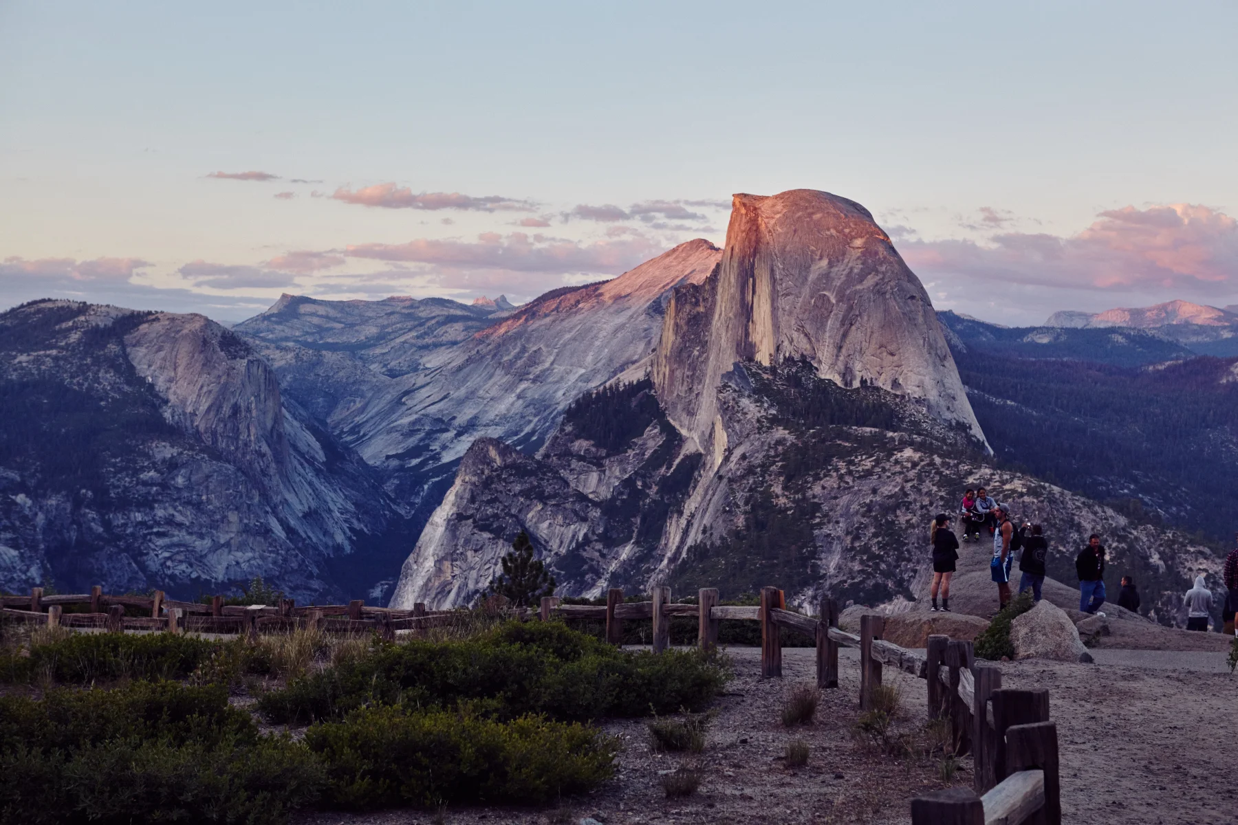
HOLY COW. WE MADE IT! //
Probably one of the most incredible feelings was making it to the top of Glacier Point, elevation 7,214 feet. I was overwhelmed, and it brought tears to my eyes to stand there and look out over what we had just hiked. I felt like I was on top of the world! The sun setting over the mountains was breathtaking. The total elevation change was 3,200 feet. And wouldn’t you know it, there was a gift shop at the top that actually had ice cream sandwiches. After 6 hours of hiking, this part was heavenly. We sat at one of the lookout points and watched the sun go down with a crowd of tourists who had decided to take the easy way and drive up to the point.


OVERALL THOUGHTS //
Hiking in Yosemite should be on everyone’s bucket list. With a variety of trails, there's something for everyone. Although tough, this was easily one of my favorite hikes. I highly recommend taking a couple of days to explore the surrounding areas and see as much of the park as possible. For $30/per car, you get seven days admission into the park. Someday I'd love to go back and get a permit to hike Half Dome.
Have you been to Yosemite? What were your favorite hikes or places to see? xx ASH