THE MOJAVE DESERT DRIVE

THE SCENIC ROUTE // 01.09.16

On our journey from Vegas to Palm Springs, we decided to take the road less traveled through the Mojave Desert. We had to take advantage of the Audi A3 we rented from Sixt - $93.38 for five days. I couldn't believe it; I thought for sure there would be a catch, but there wasn't! This rental included unlimited miles as well as the drop-off in another state, which is often a separate charge. We will be renting from Sixt from now on.

We took I-15 south until Cima Road, Exit 272 – about 24 miles south of the Nevada border. We followed Cima until it became Kelso Road. We didn't have time to visit the Kelso Dunes, but we could tell from miles away just how large they were. The highest dune is 600 ft. to the top. We'll be saving that for next time!

EERIE AMBOY //

We drove for a while, stopping now and then to take photos. Coty loved hitting the open road and escaping the congested highways. He couldn't help but hit the gas while going over the bumps - you know, like a 10-year-old would do. Ha! Finally, we saw Roy’s Gas Station in Amboy and pulled over for a coffee. As soon as I got out of the car, the atmosphere felt a bit eerie. We spotted some little white buildings with the windows and doors open. Each building had a different art installation piece. I went to explore this creepy place while Coty looked at the map to see how far we had left to go. No one was around; the doors were just swinging open with the chilly air. After a couple of minutes, I went back to tell Coty to get out and look around with me. It was not exactly what I expected – but instead of coffee, we got some cool photos. Afterward, I read that there are only eight people (all men) who live in this town. I don't think I'll ever need to go back there again.

OVERALL THOUGHTS //

This drive was smooth and absolutely beautiful. There wasn't much traffic, making it even more enjoyable. It took us about five to six hours to get from Vegas to Palm Springs. If you're interested in seeing the sand dunes, plan some extra time for that. Either way, be sure to have some snacks and water with you as things are very limited along this route.

HIKING YOSEMITE'S GLACIER POINT


GETTING INTO THE PARK // JULY 15, 2015

We stayed just outside of the park in Fresno, CA with two friends we planned on hiking with - Nick and Haze. They were pretty familiar with the trails, so they led the way! We took Highway 41 north into Yosemite and parked in the Yosemite Valley. But before catching the shuttle bus to The Mist Trailhead, we walked over to the Bridalveil Falls

SETTING OUR PLAN //

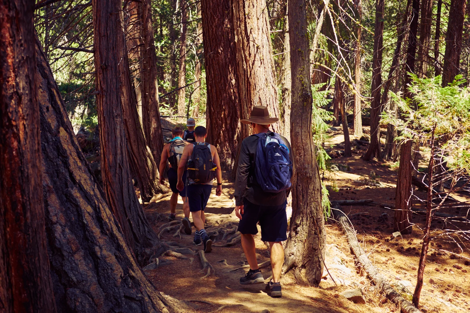
Our plan was to hike Yosemite's signature trail: the punishing but majestic Mist Trail. The 3.5 mile, one-way trail offers a steep, intimate experience of the Vernal and Nevada Falls with an elevation gain of 1,900 feet. From there, we took the Panorama Trail  to connect to Glacier Point. A 9.5 mile, one-way hike estimated at six to eight hours.

THE TRAIL // TO VERNAL FALLS

The first mile of the Mist Trail was a strenuous, paved trail, followed by a half-mile hike up a misty, granite-laid staircase that traced the Merced River. The narrow path became pretty challenging before we reached our first stop: Vernal Falls at 317 feet. It was tough to capture photos of our surroundings without a wide angle lens. Also, without people in the photos, there is no sense of scale. We spent about half an hour getting closer to the falls, climbing on the rocks amongst the mist and taking it all in. 

We then climbed the side of the falls on a path that consisted of a narrow staircase with two wires for handrails on either side. People were passing in both directions, so we had to stop and awkwardly shimmy past people. It was quite strenuous. The gusts of mist coming from the falls felt amazing, but it made the steps wet and slippery, so we had to take our time. Once we made it to the observation area at the top of Vernal, we stood looking out over the valley, breathing in all the fresh air.

LUNCH AT THE NATURAL WATER SLIDES //

We decided to take a quick lunch break and ate our PB&J sandwiches while we watched people go down the natural waterslides at Emerald Pool. The slippery granite slope, called the Silver Apron, looked pretty challenging from where we sat. I researched afterward, and there are a ton of injuries there every year; many people have even been killed after being swept over the falls. I would never take the chance, considering the remoteness and how far you'd have to walk to get help if needed. For that reason, they do not recommend swimming in this area. In fact, swimming and wading are prohibited at Emerald Pool, and signs are clearly marked advising against such recreation.

A little further up, people were relaxing in the streams and floating in the water holes. It looked incredibly relaxing. I wished we had brought our bathing suits, but I know I would have never wanted to get out of the water if I had. Next time! Also on the trail, we passed a lot of children, and I wondered what it would be like to see the scale and beauty of Yosemite with such young eyes.

ONTO THE NEVADA FALLS // 

From there we trekked on to the next set of falls, standing at 594 feet. Once we reached the bottom of the falls, we started up the super steep incline along the base of the falls on a set of rough and uneven stairs. Again, there was a decent amount of foot traffic that required us to constantly look up to see what was ahead of us on the trail; it made it difficult also to focus downward to make sure our footing was solid. At one point, I started to feel light-headed and dizzy and began questioning every step. I took a couple of breaks and wondered how I would conquer the next 8 miles. It turns out my sugar was low. Within half an hour of having a snack, I started to feel better and was able to make it to the top of the Nevada Falls. It was so amazing to be so close to such a powerful force of nature. Each leg of the trail was more difficult than the last. At this point, the elevation gain was 1,900 feet, and we were about 3.5 miles into our 10-mile hike.

CONNECTING TO THE PANORAMA TRAIL  //

We soon came to a fork in the road along the John Muir Trail. I was a little nervous when the sign read “Glacier Point 4.6 Miles” because it meant we weren't even halfway there yet. And I'd be lying if I said that I wasn't feeling a little exhausted. Nonetheless, we had a goal, and the guys gave me the encouragement I needed. For the next mile or so, the incline was very gradual and offered a nice break from the previous steep slopes. When we looked across and could see Glacier Point, I started to feel some relief to see the end in sight finally. Or so I thought. We began our decline and found it was easier to jog rather than try to brace ourselves walking. Most of the ground consisted of large rocks, loose gravel, and exposed tree roots, making it a little more interesting. As I was enjoying the journey down, I realized we still had another mountain to start back up once we reached the bottom.

ONE STEP AT A TIME, WITH THE END IN SIGHT// 

When we made it back down and crossed over the bridge, we weren't entirely sure which direction we needed to go. We asked a couple of hikers, but no one could give us a definite answer. We decided on a direction, and off we went, fingers crossed. As we started back up the mountain, we noticed a lot of hikers coming down. They looked refreshed, unlike my struggling self. They said there was ice cream at the top of the mountain; I laughed and couldn't imagine how delicious that would taste at that moment. We kept going, though, switchback after switchback.

HOLY COW. WE MADE IT! //

Probably one of the most incredible feelings was making it to the top of Glacier Point, elevation 7,214 feet. I was overwhelmed, and it brought tears to my eyes to stand there and look out over what we had just hiked. I felt like I was on top of the world! The sun setting over the mountains was breathtaking. The total elevation change was 3,200 feet. And wouldn’t you know it, there was a gift shop at the top that actually had ice cream sandwiches. After 6 hours of hiking, this part was heavenly. We sat at one of the lookout points and watched the sun go down with a crowd of tourists who had decided to take the easy way and drive up to the point.

OVERALL THOUGHTS // 

Hiking in Yosemite should be on everyone’s bucket list. With a variety of trails, there's something for everyone. Although tough, this was easily one of my favorite hikes. I highly recommend taking a couple of days to explore the surrounding areas and see as much of the park as possible. For $30/per car, you get seven days admission into the park. Someday I'd love to go back and get a permit to hike Half Dome

Have you been to Yosemite? What were your favorite hikes or places to see? xx ASH


WINDING THROUGH BIG SUR


THE SCENE //

Big Sur is a winding 90-mile coastal gem with deserted beaches and towering redwoods, where the Santa Lucia Mountains meet the Pacific Ocean. Each turn along the narrow Highway 1 is somehow more photogenic than the last. Imagine rolling down the windows, winding along the seaside cliffs as you drive off into the never disappointing sunset. Sounds quite magical, and I promise it is!

PLANNING //

Whether you plan to drive north or south through Big Sur, I suggest you spend about an hour or two planning your trip. There is so much to see, and you will want to pull over at every turn to take photos and explore along the coast. I've driven both south from San Fran to LA and north from LA to San Fran. I'm not sure which I preferred because it felt diverse each way. On both occasions, we stayed in Santa Barbara area or Carmel-Monterey area since they seem to be the closest on the north and south ends. 

Now for the planning - I highly recommend rising at the crack of dawn and getting on the road, so you have the maximum amount of time to explore. Since staying in Big Sur is expensive and often booked months in advance, I'd suggest staying in Santa Maria, Santa Barbara, or Morro Bay area if you are south of Big Sur. From the north, I'd recommend Carmel-Monterey Bay area. 

Coty and I left Ventura (where we found the cheapest place to rest our heads) around 6am and stopped in Morro Bay around 11am for some fish and chips on the dock. If traveling with a GPS, make sure you follow Highway 1, rather than the fastest route generated by the GPS. Cell service is limited so don't rely on that for anything. Bathrooms and places to eat are also limited, so pack a lunch and a roll of TP! 

I knew the timing was important since we only had one day to see Big Sur and so many things to do. I wrote everything down in advance in case my phone wouldn't work. I had each hour planned, which is not our usual method of traveling at all. 

When we stopped for lunch, Coty said we needed to hurry as he had something planned. My internal dialogue: WHAT! What do you mean you have something planned?! Didn't you see our itinerary for the day?? 

Don’t get me wrong - I love when he plans fun things, but I hate surprises. It turns out we passed on all of the things we had originally planned to see because he had arranged a surprise horseback ride for us. Best. Surprise. Ever. We rode about two to three hours through the redwoods, across rivers, and ended on the beach. If you’re a horse lover or want to try something new, I highly recommend it! 

Afterward, we drove to Bixby Bridge (photo above) and enjoyed the sunset. It was magical. 

The next day we back-tracked to some of the popular attractions we had planned to see the day before.

ATTRACTIONS //

Elephant Seal Beach - We randomly stumbled across this, and the name is literal. The entire beach is littered with elephant seals, fighting and making wild noises. Plan about 15 minutes for the stop.

McWay Falls - I don't suggest paying to park. Instead, park along the road and walk. You'll notice the popular attractions easily because you'll see cars pulled over; just go with the crowds. Then follow the footpath, and it's maybe a five-minute walk to see the 80-foot waterfall and emerald water cove. 

Julia Pfeiffer Burns State Park - A great place to hike and take in all of the coastal views. There is a fee to park your car, but you can usually find roadside parking across the street if you’re just stopping quickly. There are also restrooms and trail signs throughout the park.

Bixby Bridge - Towards the top of Big Sur, the bridge is a popular place to watch the sunset. 

Andrew Molera State Park - The Park offers beautiful beaches, campgrounds, and hiking. 

Molera Horse Back Ride - One of the best horseback rides I've taken. We chose the Redwood Roundup Ride for $114 per person. The ride was two and a half hours long, starting deep in the Redwood Forest. The light leaked through the trees onto the fern covered grounds, and it felt magical. We crossed the Big Sur River many times before we reached the Redwood Grove. I felt like I was in a Western movie crossing through the rivers! As we traveled through the meadows, the guide shared lots of cool history about Andrew Molera State Park. From there, we took the horses onto the beach and rode along the water’s edge before returning to the stables. It was a challenging ride, but ideal for anyone who is fit and knows a little about horses. 

You aren't allowed to take anything but a camera OR a phone, which has to be around your neck on a lanyard they provide. No water or backpacks - nothing. Wear a hat to shield your face/neck from the sun. This ride is something that you could also do the next day. If you stay in Carmel or Monterey, it's about 25 minutes back south - totally doable and so worth it.

THE SHORT LIST OF EATS //

The Big Sur Bakery - Heavenly for a morning shot of espresso or a donut, watching the morning light trickle through the Redwoods. 

Nepenthe - The fancy option. Stunning views and the place to splurge on a nice dinner or sunset drinks. 

Deetjens - A charming little place with a great selection of local wines. Make reservations, as this cozy dinning room can get really busy. It's a little on the pricey side, but looks amazing! 

TIPS FOR THE COASTAL DRIVE //

GIVE YOURSELF PLENTY OF TIME. Set aside four to five hours just for the roughly 85-mile drive. It will take about that to travel from Santa Barbara to Monterey and vice versa without stops. You will want to stop at every turn and will catch yourself staying longer than intended. Give yourself at least a full day to experience Big Sur. 

BE PATIENT. The route is a slow, relaxing drive and it’s often hard to take it all in at once. If you're in a rush, take the freeway. At some point you will find yourself stuck behind cars, RVs, and bikers. Cars will quickly merge on and off the road. All of that aside, just enjoy every minute of it. The views are breathtaking. 

YOU WILL LOSE SERVICE ALONG THE COAST.  Forget Google maps and Apple apps. Your phone will be pretty worthless along this drive. You'll need to know where the landmarks are, and I recommend writing things down in a notebook. 

ROLL DOWN THE WINDOWS and put on a good playlist.

DO YOUR RESEARCH. This is your chance to be Polly Planner if you have limited time here. There is so much to see and do along the way - find what interests you. Discover something adventurous to do to break up the drive and time spent in the car. 

MAKE SURE YOU HAVE SUPPLIES. Most importantly: food, water, and gas. There aren't many places to stop through Big Sur. There are a couple of gas stations, but they are expensive. Fill up your tank and have plenty of water with you. 

DON'T DRIVE AT SUNSET. It's the most beautiful time of the day. It can also be really difficult to drive when you’re staring into the sun and passing cars on windy turns. Find a place to pull off and enjoy the view. 

AIM TO STAY ON EITHER END. There will be plenty of options for accommodations with a variety of price points. I like the Carmel-by-the-Sea just north of Big Sur, or Cayucos and Morro Bay areas south of Big Sur. If camping is your thing, you can look into those options.

* UPDATE - LOOK FOR ROAD/PARK CLOSURES IN ADVANCE //

During the winter of 2017 California got a ton of rain causing major mudslides and closures throughout Big Sur. With parts of Highway 1 closed it made it almost impossible to access nearly 40 miles of Big Sur by car. 2017 was one of the toughest years for Big Sur. Before planning your trip look into current road conditions to see if there are any road,resturants or hotel closures. I feel so lucky I was able to see Big Sur twice before any of this happened. 

———————————————————

Do you have a favorite spot in Big Sur? Did you find traveling the coast as magical as me? Comment below. xx ASH

For more, read about our nearby stops in Carmel-By-The-Sea & Monterey Bay.